


Thursday, January 31, 2013
Peaceful but deceptive
Wednesday, January 30, 2013
Tuesday, January 29, 2013
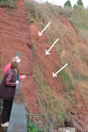
Hedgerows giving way
Just walked round the village and the incessant rain and strong winds have caused a tree to fall across Rockhouse Lane between the Courthouse and Maidencombe Farm. The lane is clear now. Further erosion of hedgerows evident in Steep Hill and Brim Hill.
Sunday, January 27, 2013
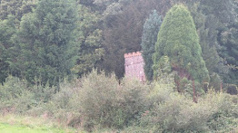
SUITE DREAMS SITE OF ARCHAEOLOGICAL INTEREST

Hal Bishop, the Senior Historic Environment Officer for Torbay Council has expressed a keen interest in what lies beneath the footprint of Suite Dreams (above) and has placed a condition to development of the site as follows: 'No development shall take place within the area indicated until the applicant has secured the implementation of a programme of archaeoligical work in accordance with a written scheme investigation submitted by the applicant and approved by the Local Planning Authority'.
There has been no move to develop the site since 2007.
Happier times - the sizing branch

Thursday, January 24, 2013
Tuesday, January 22, 2013
Flashback to December 18th 2010
First snow flurries in the combe
Monday, January 21, 2013
RETURN OF THE FIRE HASH

WAITRESS SERVICE IN THE COMBE
Sunday, January 20, 2013
Skullduggery at the Cross bus stop?


Saturday, January 19, 2013
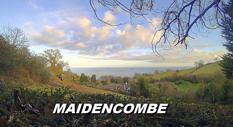
First glimpse of Maidencombe from the north

Confused? Many visitors are.

THE PERCH - SOUTHERN GATEWAY TO MAIDENCOMBE

Friday, January 18, 2013
BLUEBELL & TIPLEY FINCH


Thursday, January 17, 2013
VIEW FROM LYME'S WEEP LOOKING SOUTH

VIEW FROM LYME'S WEEP LOOKING NORTH

This is Maidencombe and not Watcombe

Wednesday, January 16, 2013
MAIDENCOMBE MAP PRESENTATION & TALK
There was a map presentation and talk on Maidencombe given by Jim Campbell last Monday at the St Marychurch Community Partnership meeting held at Westlands School, Plainmoor.
The talk lasted thirty minutes with all three St Marychurch councillors present along with Torbay Council representatives and Susie Colley, the Chair of the Torquay Neighbourhood Forum.
Mr Campbell identified the boundaries, Torbay Coast & Countryside leased fields and the permissive routes that ran through Maidencombe.
Every stile and kissing gate was marked on an A1 sized draft map which the audience could follow on specially printed A4 maps distributed for them to peruse.
It was also revealed that all of the TCCT's fields had names and nicknames (rather than the Council's numbered & lettered versions) dating back many years. A few were mentioned such as Tipley Finch (Tiddly Pinch), Gypsy, Lyme's Weep, Bluebell and Cade's.
It was established that the southern entrance to Maidencombe was at the 'Perch' a seat and viewpoint at the summit of the Goats Path from the Valley of the Rocks.
There were a number of questions posed at the end of the presentation.
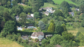
Torbay Council sells parcel of land in northern Maidencombe

Confusion was caused by the size of the land - 2.2 acres - which is identical to that of Bowden Meadow at Maidencombe Cross.
The land sold is situated at the very northern reaches of Maidencombe, some 80 metres to the NW of Whiteway Lane inland of the A379 (see illustration). The auction realised £46,000 for the Council, exceeding its estimate by some way.
The land in question is part turf and part woodland with views across the bay and it raises the question what the buyer has in mind for the plot of land.
The auctioneer's notes reveal this:
Interest is anticipated from equestrian and small-scale farming types as well as those on the lookout for a stunning tucked away but readily accessible piece of Devon for occasional recreational tenting and caravanning purposes.
Monday, January 14, 2013


Tugboat drama off Hopes Nose - towed ship sinks

She was towing the EMSSTROM, a German training ship en route for Turkey to be scrapped.
The tow became unstable and while coming in closer the EMSSTROM apparently holed the tug which began to take on water.
The drama unfolded about a mile off Hopes Nose and could clearly be observed from Maidencombe as two lifeboats from Torbay and Exmouth, the Brixham harbour tug and two Royal Navy vessels HMS Lancaster and HMS Severn stood by. The RAF search and rescue helicopter from Chivenor and the Torbay Coastguard Rescue Team were also called to assist.
The tug BRENT came alongside and pumps temporarily stabilised the stricken vessel. Salvage was attempted but there is a concern over possible oil spillage
The EMSSTROM has subsequently sunk but with no pollution fears.
Dry in the combe
I really cannot recall the last time there were dry roads in the combe. A most pleasant change was the walk up Brim Hill without the water leaking from the water main which seems to have been repaired. The run-off of surface water from the north exiting half way down Steep Hill has also dried up. The Maidencombe spring is now only weeping a little water onto Rock House Lane and Orchard Lane is nigh on negotiable without waders.
Dry and still as So Cruise and I wended our way around the combe on our Night Patrol and most enjoyable it was too, though temperatures are due to plummet the next few nights.
Dry and still as So Cruise and I wended our way around the combe on our Night Patrol and most enjoyable it was too, though temperatures are due to plummet the next few nights.
Saturday, January 12, 2013
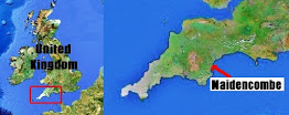
Valley of the Rocks and the boundaries of Maidencombe
Research on our Maidencombe map has yielded quite a few results already - particularly with regard to defining the boundaries of Maidencombe, which have long been clouded in mystery. The southern borders of Maidencombe have always been a topic for discussion with the Torbay Coast & Countryside Trust placing wooden signage posts a full quarter of a mile inside of the summit to the Goats Path bearing the legend: 'Area of Watcombe' and supported by an SX grid reference. These look authoritative but I have always been dubious of their validity and had posed the query to the Trust's Director who had not been dogmatic in replying 'Have we got them in the wrong position?'
----------------------------------------------------------------------------------------------------------
Well, they are in the wrong place and should be changed at some point. I confirmed this after making a visit to the Town Hall Friday afternoon to inspect the ward boundaries. It may even come as a surprise to some that the Valley of the Rocks (listed on the English Riviera Global Geopark website as Watcombe) and indeed Watcombe Beach both lie outside of the Watcombe Ward boundary courtesy of the radical changes of December 2001 when Maidencombe changed wards, moving from Combe Ward (renamed Watcombe Ward) to the St Marychurch Ward. There is even a possibility that Maidencombe could even lay claim to the Valley of the Rocks and the Giant Rock ... more on this later.
-----------------------------------------------------------------------------------------------------------
SWW now repairing leak
After being notified of the reoccurring leak at the top of Brim Hill, SWW operatives have dug a trench and cordoned the section of road off. You are advised to use Steep Hill to enter the village weekdays from 8 am to 5 pm as congestion from works vehicles at Brim Hill Villa is severe.
Friday, January 11, 2013
Thursday, January 10, 2013
Wednesday, January 09, 2013
Neighbourhood Plan banner
You will note that a Neighbourhood Plan information banner has been positioned on the council owned (permission approved) grass verge immediately after the bus stop bay before the Rock House Lane turn. This was done at the behest of the Neighbourhood Forum. I assisted local councillor Alan Faulkner with the operation.
Confirmed water leak Brim Hill
Confirmation of a water leak at the top of Brim Hill. Highways and SWW to be informed.
Monday, January 07, 2013
Appearing all over the village

Friday, January 04, 2013
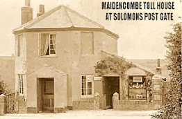
There's a Coach Coming In ...

The double-decker draws in at Maidencombe Cross bus stop to drop off a resident. In the summer months, it is a mystery to tourists where the actual bus stop is as there is no 'sign' of one nowadays. You have to go back a few decades to when there actually was one ...
Horse & pony in Bowden meadow

Thursday, January 03, 2013
Another leak in Brim Hill?

Wednesday, January 02, 2013
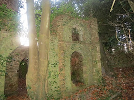
Deep in the heart of Sladnor Park

Tuesday, January 01, 2013
Subscribe to:
Posts (Atom)